in Twin Mountain Bretton Woods
We are the closest location to the west side of Mount Washington, where several popular trailheads begin, including The Cog base road. As the quieter side of the mountain, we make the perfect location for hikers to stay and play.
Hiking in the White Mountains of New Hampshire provides an outdoor experience like no other. Whether basking in the warmth of an afternoon summer sun, gazing at the vibrant colors of an autumn forest, or rising to the challenge of a winter ascent, hikers of all ages and ability levels are sure to find a new favorite place in the White Mountains.
What To Bring on a Hike
Here is a list with recommendations of what to bring on a day hike.
For a more complete list covering all seasons, visit NH Fish & Game Department website.
- Map & Compass
- Warm Clothing – Extra Sweater or Jacket, Long Pants (wool or synthetic)
- Extra pair of socks
- Hat
- Extra Food and Water
- Flashlight or Headlamp (with extra batteries)
- Matches (store in a waterproof container)
- First Aid Kit
- Whistle
- Rain Gear
- Pocket Knife
- Insect Repellant
- Sunscreen
Helpful hiking information can also be found at the US Forest Service Hike Safe website.
Start Your
Adventure
Download Our Free Guide

Popular Hikes in the White Mountains
AMMONOOSUC FALLS (upper Falls)
(Bridle Path 1.4 miles – 45 min.) Beginning at the Mt. Washington Hotel tennis courts, the path follows the river through evergreen forest and joins an old railroad bed which leads to the falls. This series of cascades through a narrow gorge is one of the area’s most interesting natural features.
AROUND-THE-LAKE-TRAIL (Ammonoosuc Lake)
(round trip: 3.6 mi, easy) An easy scenic loop hike around Ammonoosuc Lake near the AMC’s Highland Center Lodge.
CHERRY MOUNTAIN (3554′)
(Black Brook Trail 5.4 miles – 3 hr. 10 min.) Trail begins half a mile west of Zealand Campground on Route 302. Easy through hardwood forest. Summit offers beautiful view of Presidential Range.
CRAWFORD NOTCH to SUMMIT of MT. WASHINGTON
(Crawford Path 8.2 miles – 6 hr.) Trail begins directly across from the former site of the Crawford House on Route 302. A more demanding hike offering rewarding views. The trail crosses the entire southern Presidential Range. 5 miles of the path lies above the timberline.
ETHAN POND
(round trip: 5.4 mi, moderate) The Ethan Pond Trail passes through semi-open bogs and forest, leading to a scenic backcountry pond. From here you also have a view of the Twin Range.
ELEPHANT HEAD
(round trip: 0.6 mi, easy) – Follow the Webster-Jackson Trail for 0.1 mi to the Elephant Head Spur, the gray rock here is striped with veins of white quartz. This mass of rocks resembles an elephant’s head and trunk. The spur trail ascends to the summit of the knob and open ledges that provide views of Crawford Notch. A fair easy hike. Some parts are a bit rugged and muddy, however the trail is only about a third of a mile each way.
LAKES OF THE CLOUDS (5050′)
(Ammonoosuc Ravine Trail 2.5 miles – 2 hr. 45 min.) Trail starts at Cog Railway base station. Following the Ammonoosuc River, the trail passes the base of the Ammonoosuc Ravine, then the steep trail ascends to the lakes. May continue from lakes to Mt. Washington summit.
MT. EISENHOWER (4761′)
(Edmand’s Path 3.2 miles – 2 hr. 40 min.) Trail leads from the east side of Mt. Clinton Road to the summit of Mt. Eisenhower. One of the easier trails up onto the Presidential Range. An excellent view of Bretton Woods Valley.
MT. JEFFERSON (5715′)
(2.4 miles – 2 hr. 40 min.) Trail starts at height of land on Jefferson Notch Road and ascends the west slope of Mt. Jefferson. Timberline is reached in half an hour. From there, steep grade and rocky terrain lead to a panoramic view of the northern Presidential Range.
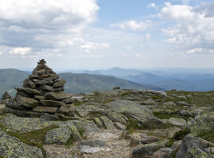
MT. WASHINGTON (6288′)
(Jewell Trail 4.6 miles – 3 hr. 55 min.) Trail begins at the Cog Railway base station. Winding and zigzagging through rugged forest, the trail works its way up to the north shoulder of Mt. Washington and from there on to the summit. Alpine shrubs and flowers. At the summit are a cafeteria, gift shop, post office and museum.
MT. WEBSTER (3910′)
(Webster-Jackson Trail 2.5 miles – 2 hr. 15 min.) Trail begins behind road camp by Saco Lake in Crawford Notch. The steepness of this trail varies as it skirts the top of Webster Cliff. Breathtaking view of Crawford Notch.
MT. WILLARD (2804′)
(Mt. Willard Trail 1.4 miles – 1 hr. 10 min.) Excellent short hike. Trail starts at the old Crawford House Railroad Station opposite Saco Lake. An easy grade up an old carriage road leads to a spectacular view of Crawford Notch.
SUGARLOAF (2526′)
(Sugarloaf Trail 1.2 miles – 1 hr. 30 min.) Trail starts 1 mile up Zealand Road at bridge over Zealand River. Going through open hardwoods, the trail splits between Middle and North Sugarloaf. Bear left to Middle Sugarloaf for better view.
ZEALAND VALLEY
(Zealand Trail 2.7 miles – 1 hr. 30 min.) Starting at the end of Zealand Road, the trail rises gently on an old railroad bed leading to open meadows teeming with wildlife. At the far end of the valley lies Zealand Pond, Zealand Falls and the AMC Zealand Falls hut.